WASHINGTON D.C January 23, 2026 – The White House has emphasized the National Weather Service’s (NWS) preparedness for an oncoming winter storm that could impact over 235 million Americans across more than 40 states, stretching 2,000 miles from the southern Plains to New England. In a post on X, the White House stated, “@NWS IS READY: ‘We’ve been able to be ready for every hurricane. We’re ready for hurricane season. We’re ready for severe weather season, and we’re ready for this winter weather season.'”post:0 This assurance comes as forecasters warn of heavy snow, crippling ice accumulations, and brutal cold that could lead to prolonged power outages, hazardous travel, and life-threatening conditions.
The storm, described by experts as one of the most expansive in years, began developing over the Plains on Friday, January 23, and is expected to intensify through Monday. NOAA’s hurricane hunter aircraft, typically used for tropical storms, are being deployed in a rare multifront effort over the Pacific and Gulf to gather critical data via dropsondes—probes that measure atmospheric conditions as they descend. NWS Director Ken Graham highlighted the complexity of the forecast, noting, “Little wiggles matter, so 1 or 2 degrees in either direction could be rain or freezing rain or snow. North and south 40 or 50 miles could put a major city in the ice or the snow or just rain.” Despite recent layoffs at NOAA, Graham affirmed the agency’s readiness, stating they “haven’t missed a beat.”
Forecast and Regional Impacts
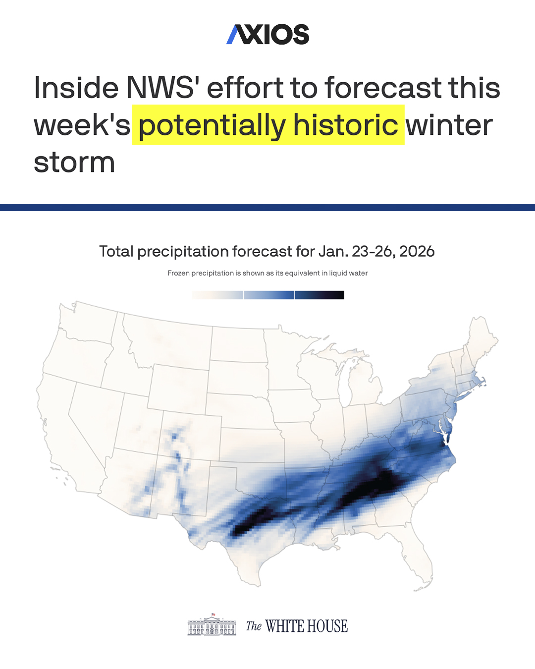
Forecast models show the storm delivering up to a foot of snow in areas unaccustomed to such accumulations, with significant ice buildup—up to 1 inch in parts of northern Mississippi and northwestern Alabama—posing risks of catastrophic tree damage and extended blackouts. More than 160 million people are under winter weather alerts for snow, sleet, or freezing rain, while extreme cold warnings cover two-thirds of the US, with temperatures plunging to levels not seen since 2021 in some regions.
Key areas at risk include:
- Southern Plains (e.g., Dallas, Fort Worth): Freezing rain starting Saturday, with 0.25-0.50 inches of ice and 1-3 inches of snow, leading to impassable roads.
- Mid-South (e.g., Little Rock, Memphis, Nashville): Heavy ice accumulations over 0.5 inches, potential for “historic” ice in Memphis, causing power grid strain.
- Ohio Valley and Midwest (e.g., Louisville, Indianapolis, Cincinnati): 6-12 inches of snow, with central Ohio under Winter Storm Warnings and temperatures in the single digits.
- Mid-Atlantic and Northeast (e.g., Pittsburgh, Washington D.C., Philadelphia, New York, Boston): A mix of snow and ice, with 8-12 inches possible in some spots; subzero wind chills by Sunday.
A forecast map from NOAA’s Global Forecast System illustrates heavy frozen precipitation equivalents concentrated in the Southeast, with impacts spreading northward.
Preparations and Public Response
Airports like Hartsfield-Jackson in Atlanta are gearing up for disruptions, with potential flight cancellations amid the storm. Local NWS offices, such as in Tulsa, have issued updates urging residents to prepare. On social media, users are sharing lighthearted takes alongside warnings, with posts about stocking up on essentials and humorous nods to being snowed in. Meteorologists like Max Velocity are providing live streams with the latest model updates.
Graham advised the public to prepare generators safely, avoid overexertion while shoveling, and steer clear of downed power lines. As the storm unfolds, officials stress that its slow-moving nature could prolong dangers, with icy conditions lingering due to the arctic air blast.
Life News Agency will continue monitoring developments as this historic weather event progresses. Residents in affected areas are urged to stay informed through local alerts.