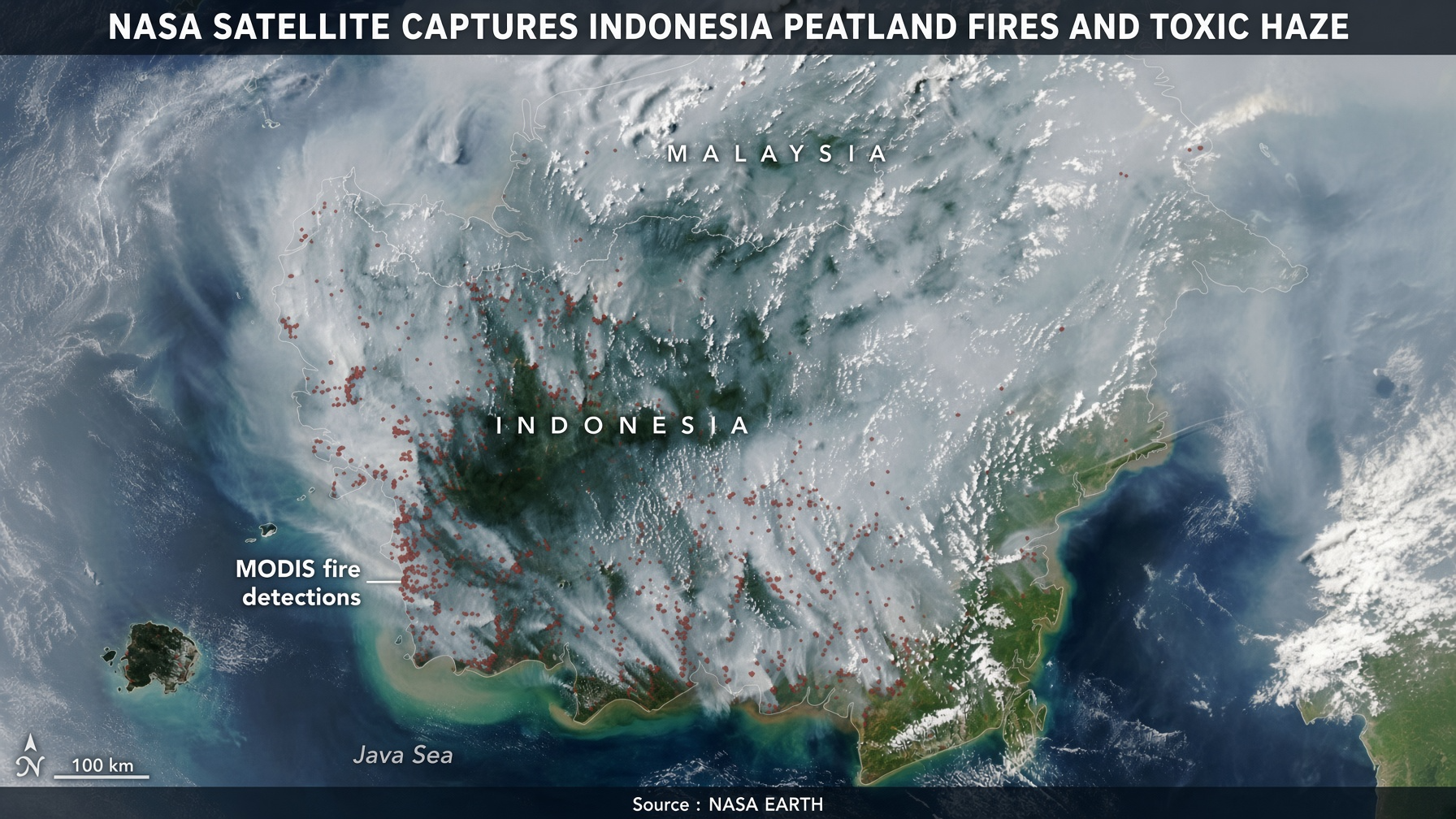
FLORIDA Sept 3, 2026 – A NASA Aqua satellite image from September 1, 2026, shows vast plumes of smoke covering much of Indonesia and neighboring Malaysia, with dozens of thermal anomalies indicating active fires concentrated on the southern side of Borneo.
The image, highlighted by NASA Earth, captures fires that have been burning for weeks amid one of the country’s driest periods in years. Many are tropical peatland fires that smolder slowly underground rather than racing across the surface. These fires release far more air pollution than typical forest burns—roughly three times the fine particulate matter, five times the sulfur dioxide, and elevated levels of methane and carbon monoxide—and they are notoriously difficult to extinguish until heavy rains return.
Indonesia holds about 36 percent of the world’s tropical peatlands. Decades of drainage canals built for agriculture and plantations have lowered water tables, leaving the carbon-rich soils highly flammable once they dry out. A strengthening El Niño combined with a positive Indian Ocean Dipole has suppressed rainfall; about 90 percent of the country received little to no rain in early August.
By early September the 2026 fires, active for roughly a month, had already released about 10 percent of the greenhouse gases emitted during the catastrophic 2015 fire season, which totaled 1.75 billion tons. Indonesia’s SiPongi monitoring system, which uses NASA MODIS and VIIRS data, recorded 946 hotspots on August 31.
The smoke has created a regional health and environmental crisis. Millions of people in Sumatra and Kalimantan have been exposed to hazardous air. Reports indicate tens of thousands of hospital visits for respiratory infections. Haze has crossed into Malaysia, where some areas recorded “unhealthy” or “hazardous” air quality, prompting school closures and indoor events, and has been detected as far as the Philippines. Several Indonesian national parks closed and flights were delayed. Wildlife, including endangered orangutans, has also suffered, with some animals found weak and requiring treatment.
Indonesian authorities have responded with a mix of enforcement and firefighting. The Environment Ministry launched proceedings against 21 companies linked to more than 11,400 hectares of burned land. Police earlier arrested 72 people suspected of starting fires, many tied to illegal land-clearing. Officials have deployed water-bombing helicopters, cloud-seeding aircraft, ground teams, peat-wetting operations, new wells, and canal blocks. President Prabowo Subianto has visited affected areas and ordered additional infrastructure while warning of strict action against perpetrators. Forestry Minister Raja Juli Antoni described September as “the main fight,” noting that El Niño is expected to peak this month.
Experts note that while peat restoration efforts in recent years have reduced fire risk in some areas, the current drought is testing those gains. Fires often persist underground even after surface flames appear gone, requiring sustained rainfall—typically expected in October or November—to fully suppress them.
The satellite view underscores both the scale of the current outbreak and the long-term challenge of managing Indonesia’s drained peatlands during increasingly intense dry seasons.
About The Author